

Nature Park's Geography and Geology
Geographical Overview.
The Lessinian territory extends across 820km² between Veronese Province and that of Trento and it is geographically situated in the south-eastern part of the Alpine range in the Venetian Prealps. Its borders are well defined by the rift in the Adige's glacial valley to the west, the deep incision of the Val dei Ronchi in the north and the urban and agricutural areas on Veronese plains of the south.The eastern border, which is less well defined, is outlined by the ridge which separates the Val d'Alpone from that of Valle del Chiampo of Vicenzia.
From the flat foothills to its peaks, Lessinia can be divided into three different terrains, each one recognisable by its natural and man-made characteristics: the foothills and hill areas, which extend from the valley floors up to 600/800 metres on the ridges, where you can find some widespread winelands and cherry and olive plantations; The Mid Mountain areas, between 800 and 1200 metres,where you can see the main urban areas and typical Lessinian fractions; The High Pastures, between 1200 metres and the eastern peaks which are over 1800 metres, are characterized by the over 1000 Malghe(alpine farmsteads) and the dense beech and fir forests which occupy the more ardiuous slopes.
Through careful observation of the Lessinian territory it is possible to identify a fouth subzone that, even though in terms of elevation may be included in the other three divisions, has specific characteristics; this is the vaj and valley area. It is along the steep slopes of these narrow basins and dips that one finds the densest Monti Lessini vegetation. While these wooded areas can not truly be defined "natural" as for centuries man has used them for firewood and coal, it is still in this area that Lessinian wildlife has been conserved and allowed to proliferate. Opening up from areas of the High Pastures i vaj dell’Anguilla, dei Falconi e della Marciora cut through the High Lessinian mountain and flow into the wide Val Pantena valley. Deeper valleys cut through the whole of Lessinia from the mountains to the plains as in the case of the the Illasi valley or Squaranto valley, or descending from the high hills as with the Fumane, Marano e Negrar valleys in the west and the Mezzane, Tramigna or d’Alpone valleys in the east.
Since 1990 the steep slopes of these vaj along with most of the high pastures and some smaller areas of interest with specific natural characteristics have been an integral part of the Lessinia Regional Natural Park, which extends for little over 100km²,between the Veronese province and Province of Vicenza.
Geology
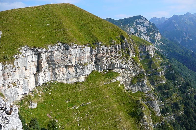
Dolomite Stone (220 – 210 milion years) makes up the entire base layer of the Lessinian Prealps,seen only at surface level in corrispondence with the deep slopes cutting into the valleys of Val dei Ronchi, Val' d'Adige and Val d'Illasi; The Grey Limestone group, divided into various formations (between 200 and 185 million years) is characterized by the widespread presence of Bivalve Fossils, amongst which the famous lithiotis, whose fossils are easily seen in various parts of the highland. Another characteristic of the Grey Limestones are the dinosaur imprints ,contemporary to the more famous ones in Rovereto, these are found on the eastern slopes of the Bella Lasta just before Revolto valley. The Oolite Limestone (185 – 175 million years) is characterised by deposits of carbonate mixed in with organic elements whose fossils are typical of that of a barrier reef.
The long period from 175 ai 135 million years marks the deposit of that which is perhaps the most characteristic formation of the Lessinia territory, in other words Red Veronese Ammonite. This rocky stratigraphy, which is quite hard and compact, is rich in Ammonite Fossils; ancient cephalopoda that inhabited the shallow seas which distiguished the period in which these rocky deposits took place.
In the Lessinian area, in corrispondence with the Oolite Limestone and Red Vereonese Ammonite stratigraphy, water erosion and atmospheric erosion brought about the formation of great natural monuments such as the Ponte di Veja (natural bridge) e il Covolo di Camposilvano (cave/den),specific Karst phenomenon such as sinkholes, abysses, and caves and other geological singularities such as the many "City of Rocks" formations found in the high pastures, among which the most famous being that of Valle delle Sfingi near Camposilvano.
More recent are the Maioliva (Biancone) formations (135 to 90 million years ago) deposited in deep seas. This stratigraphy characterizes the gentle outcrops of the highland summits and the formations' characteristic features are those of whitened rocks mixed with nodes of flint, the remains of ancient diatom shells.
Between 90 and 70 million years a series of layers of what is known as Scaglia Variegata or Red Scaglia, distinguished by its pinkish-red colour due to the iron oxide found within it, was deposited almost exclusively in the central eastern part of Lessinia. A specific section of this is identified as Lastame Calcareo and is still the prime material used in extraction and the manufacturing of stone products today.
Lastly the Limestones from the Eocene and Paleocene ages, which are usually a yellowish-white colour and generally made up of loose stratigraphies, are seen in many hilltop areas of Lessinia. It is also possible to see them near Bolca in the north eastern part of Lessinia between the Provinces of Verona and Vicenza, where in some specific sites people have been extracting splendid examples of fish fossils and other perfectly conserved organisms from inside of these rocky stratigraphies for centuries.
Completing the panorama of geological formations in Lessinia are the igneous basaltic rocks deposited during the Paleocene, and found specifically in some areas of the Valpolicella and above all in the valleys of Eastern Lessina ,where they distinguish the Val d'Alpone and Val del Chiampo territories.
(Archivio Parco Naturale Regionale della Lessinia)


